The Routeburn Track is one of New Zealand's premier walks, and part of the New Zealand Great Walks network. This ultimate alpine hiking adventure rewards you with spectacular vistas of dramatic alpine peaks, jaw-dropping valleys and stunning beech forests and takes you deep into the Mt Aspiring and Fiordland National Park Wilderness areas...
The Routeburn Track is an absolute must-do hike, and rated one of the best hikes in the world!
Routeburn Track Introduction
The world-renowned Routeburn track is a 33 km tramping track in the south of the South Island traversing both Mt Aspiring and Fiordland National Park, and which and can be walked in either direction, starting at either the Divide in Fiordland National Park off Milford Road, or from the Routeburn River just over an hour from Queenstown in Mt Aspiring National Park. As the hike is one-way in either direction, transportation at either end is required to get you back to the beginning. Talk to us about the available options.
The walk can be done over 2, 3 or 4 days depending on your level of fitness and the amount of time you have.
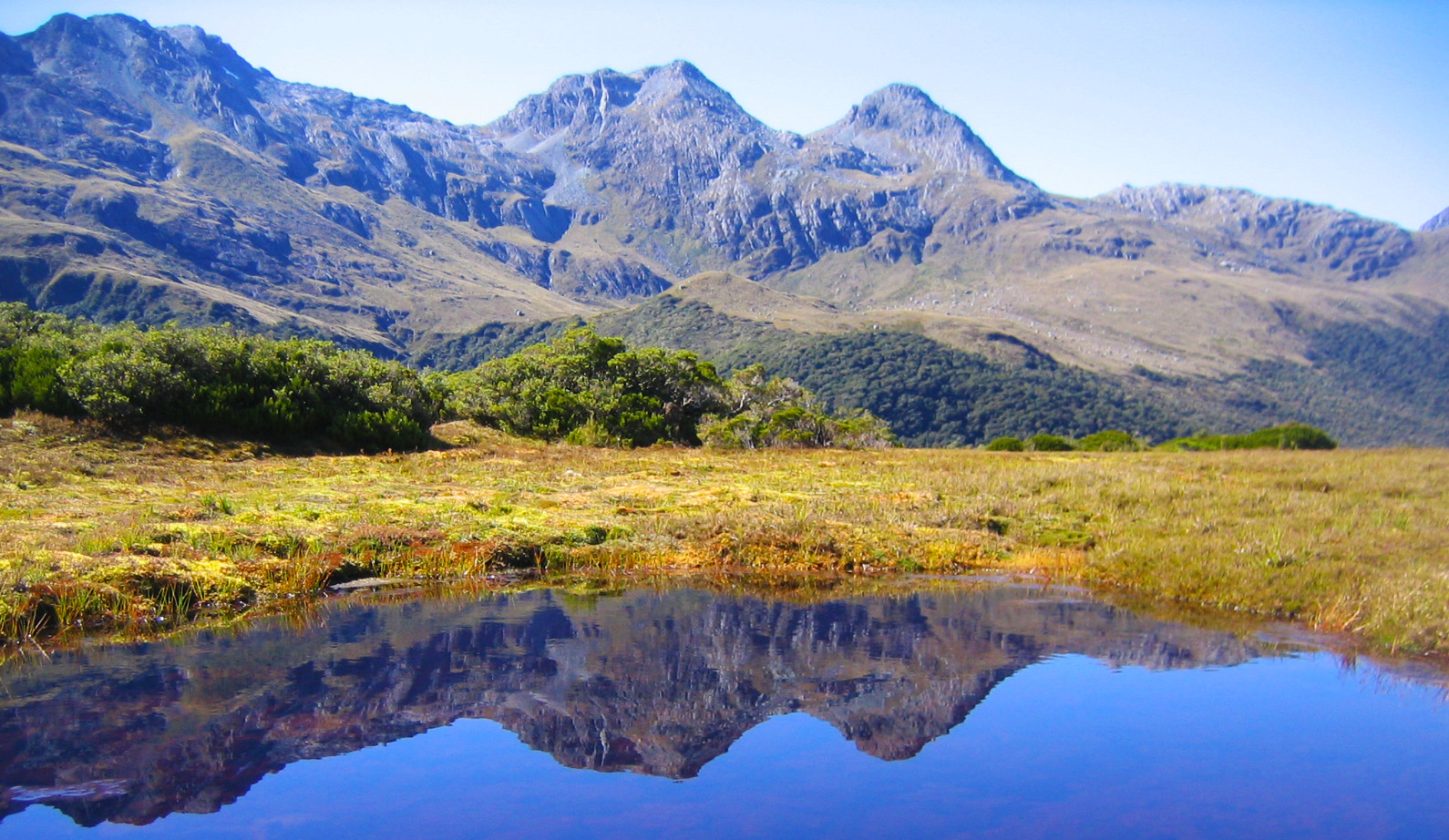
But it's not your legs that will be tired the most after this trek, it will be your eyes. They'll be doing massive overtime and working from the start to finish, the scenery is so ridiculously magnificent!!

What makes the Routeburn Track one of the best hikes in the world
- The Routeburn Track offers some of the most dramatic and spectacular alpine scenery in the world.
- A incredible diversity and variety of landscapes each day, with one day entirely above the bushline.
- The Routeburn crosses two of the most spectacular National Parks in New Zealand, Mt Aspiring and Fiordland National Park
- Pristine beech forests, alpine lakes, dramatic snow-capped mountains, deep valleys, waterfalls, untouched wilderness,this track has it all!
- Experience all four seasons during your hike (well at least 3), adding even more scenic drama to the already stellar vistas.
- Get a glimpse of some of New Zealand's rarest native birdlife
- Suitable for people of most ages with a reasonable fitness levels.
Routburn Track Quick Facts
- Track length : 33 km
- Duration : 2,3 or 4 days depending on level of fitness.
- Best time to visit : End of October unti early May.
- Difficulty : Moderate level of fitness required
- Age : Not suitable for children under the age of 10.
- Bookings : Bookings are required for huts and campsites (well in advance!
- Total elevation gain : Approximately 1300m spread across the three days
- Weather : Prepare for alpine weather conditions, any day, any time of year.
Routeburn Track Profile

Routeburn Track Day by Day
Day 1: Routeburn Shelter to Routeburn Falls
3–4 hours, 9.8km
The track begins at Routeburn Shelter, gently winding alongside the crystal-clear Route Burn (river). After passing Sugarloaf Stream, you’ll climb to Bridal Veil Waterfall and continue above the gorge. A swing bridge leads to open grassed flats, and the Routeburn Flats Hut and Campsite. The track then climbs steadily through stunning beech forest, providing views of the Humboldt Mountains. End the day at Routeburn Falls Hut, on the edge of the bushline and close to the impressive Routeburn Falls cascade.
Day 2: Routeburn Falls to Lake MacKenzie
4 hours 30 minutes – 6 hours, 11.3km
On day 2, you’ll climb steadily up the valley, through wetlands and tussock-covered flats, before sidling along the bluffs above Lake Harris to reach the highest point on the track at Harris Saddle/ Tarahaka Whakatipu (1,255 metres). The track then descends and traverses along the exposed Hollyford Face, with expansive views over the Darran Mountains. This section of the track is well-known for its impressive array of alpine plants. A steady descent leads to Lake Mackenzie Hut, set beside the enchanting Lake Mackenzie.
Day 3: Lake Mackenzie to The Divide
4 hours – 5 hours 30 minutes, 12km
Leaving Lake Mackenzie Hut, the track crosses a small flat before climbing to the bushline. A gradual descent then leads past the ‘Orchard’, an open grassy area dotted with ribbonwood trees, to the impressive Earland Falls (174 metres). The track continues its descent through beech forest to Lake Howden Hut and on to The Divide. A popular side trip (1 hr 30 min) to Key Summit climbs to an alpine wetland with panoramic views over Fiordland mountains and alpine lakes.
Did we mention it is also one of New Zealand's Great Walks
The Routeburn Track is one of New Zealand's Great Walks and therefore requires permits to access. The New Zealand Great Walks only allow a limited number of people on the track each day, and combined with its immense popularity, availability becomes limited pretty quickly. In fact, demand for this hike is so high that bookings should be made many months in advance to guarantee your spot in one of the hut accommodations on the track...!!
The huts along the track are well serviced and include bunk beds, gas stoves for cooking, wooden fireplace, toilet and friendly hut wardens. The huts contain bunk beds, and unless you're early and lucky enough to score a single bunkbed, you'll be sharing a bunk that sleeps up to eight people, so that means a lot of snoring after a long day's walk. It is therefore highly recommended to bring some decent earplugs.
For those limited on time or who didn't manage to book accommodation in the huts, it is still a fantastic experience to spend one full day on the Routeburn Track. From the Divide road end, the 3-4 hour return walk to Key Summit is a phenomenal short day walk, showcasing dramatic alpine scenery and deep valleys with incredible vistas. The walk to the Routeburn Flats from the Glenorchy side is also a great day option with cascading waterfalls, beech forests and the mighty impressive Routeburn Valley.


When to hike the Routeburn
Hiking the Routeburn Track is generally undertaken from late October until early May.
Winter is not a suitable time due to snow and avalanche risk. You need to be experienced and well prepared for hiking in New Zealand winter season
Which weather to expect on the Routeburn Track
Weather on the Routeburn Track is, well fairly unpredictable, and that's putting it mildly. It is simply impossible to book this trip with continuous good weather in mind, even during summer, so come prepared and bring clothing for any weather conditions.
This region of New Zealand receives an annual rainfall between 4-5m, and that's a lot of rain! Don't let it put you off though, even in wet weather conditions nature here provides for a different spectacle with many thundering waterfalls cascading down the steep mountain sides. The track can get flooded at times, so it is imperative you do check the weather conditions before venturing out.
As the Routeburn Track is an alpine hike which includes almost an entire day above the bushline, also prepare for cold weather, as it can go from warm temperatures to freezing weather conditions pretty rapidly.
Getting There
The Routeburn Shelter can be accessed by road on partically unsealed road, about 25km (30 minutes) from Glenorchy.
The Divide Shelter is about 85km from Te Anau towards Milford Sound along the Milford Road

What to bring
You're going on a multi-day hiking adventure in some of the most beautiful scenery on the planet, so now what should you bring along?
You won't be able to buy food on the track, which means you'll have to carry it yourself. You might be exposed to the full force of the elements at times, that means bringing clothes for all of these conditions.
So here's a list that may guide you to prepare yourself for the Routeburn Track:
Personal Equipment:
- Backpack (40-60 litre size for multi-day hiking)
- Waterproof/plastic backpack liner
- Sleeping bag (3/4 season)
- First Aid Kit (including insect repellent, sunscreen, blisterkit, personal medication)
- Survival kit (survival blanket, whistle, paper, pencil, high energy sncak food)
- Drink Bottle (1-2l)
- Eating and cooking utensils
- Matches or lighter in waterproof container
- Toiletries
- Torch/flashlight
- Rubbish bag
- Hut tickets and ID
- Portable stove and fuel
- Toilet paper
Clothing:
- At least one set of clothes to walk in, and another dry set to change into at night
- Walking boots or firm footwear
- Socks (wool/polypropylene)
- Quick drying shorts
- Shirts (wool/polypropylene)
- Under layers top and bottom (wool/polypropylene)
- Mid-layers (wool or fleece)
- Raincoat (wind and waterproof with hood)
- Overtrousers (wind and waterproof)
- Warm hat and gloves
- Sunhat/sunglasses
- Extra socks
Must-take
- Camera, surely you're not going to do this hike without capturing it on camera
- Earplugs
Bring food that's lightweight, fast cooking and high in energy value.
Routeburn Track all you need to know video